Content for TS 23.434 Word version: 19.2.0
0…
4…
5
6…
6.4…
6.5…
6.5.3…
7…
8…
8.2.2…
9…
9.3…
9.3.2.21…
9.3.3…
9.3.6…
9.3.11…
9.3.13…
9.3.14…
9.4…
9.4.6…
9.5…
10…
10.3…
10.3.2.22…
10.3.3…
10.3.7…
10.3.10…
10.4…
11…
11.3…
11.3.3…
11.4…
12…
12.3…
13…
14…
14.2.2.2…
14.3…
14.3.2.20…
14.3.2.40…
14.3.3…
14.3.3.3…
14.3.4…
14.3.4.6
14.3.4.7…
14.3.4A…
14.3.4A.3…
14.3.4A.4…
14.3.4A.6…
14.3.4A.8…
14.3.4A.9…
14.3.4A.10…
14.3.5…
14.3.6…
14.3.9…
14.3.12…
14.4…
15…
16…
17…
18…
A
B…
8.2.2 SEAL server(s) deployment in VAL service provider domain
8.2.3 SEAL server(s) deployment outside of VAL service provider domain and PLMN operator domain
...
...
8.2.2 SEAL server(s) deployment in VAL service provider domain p. 43
Figure 8.2.2-1 illustrates deployment of the SEAL server(s) and the VAL server(s) in VAL service provider domain.
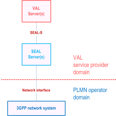
Figure 8.2.2-2 illustrates deployment of the SEAL server(s) which connects to the 3GPP network system in multiple PLMN operator domain.
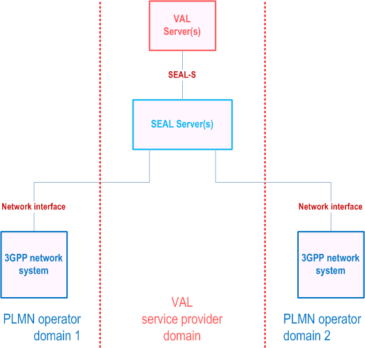
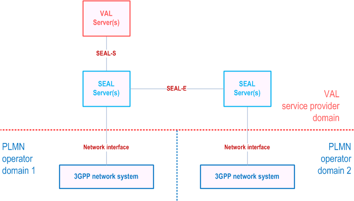
Figure 8.2.2-3 illustrates the deployment of multiple SEAL servers in the VAL service provider domain where SEAL server 1 and SEAL server 2 connect with 3GPP network system of PLMN operator domain 1 and PLMN operator domain 2 respectively. The SEAL servers interconnect via SEAL-E and support the VAL service provider domain applications for the VAL UEs connected via both the PLMN operator domains.
8.2.3 SEAL server(s) deployment outside of VAL service provider domain and PLMN operator domain p. 45
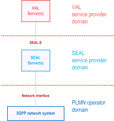
Figure 8.2.3-1 illustrates deployment of the SEAL server(s) outside of both the VAL service provider domain and PLMN operator domain i.e. in SEAL provider domain.
![]()
![]()
![]()