Content for TS 38.305 Word version: 18.1.0
1…
4…
5…
6…
6.5…
6.7…
7…
7.3A…
7.4…
7.6…
7.11…
7.12…
8…
8.1.2.1a…
8.1.3…
8.2…
8.3…
8.4…
8.5…
8.6…
8.7…
8.8…
8.9…
8.10…
8.11…
8.12…
8.13…
8.14…
8.15…
A…
8.15 SL positioning and ranging
8.15.1 SL-PRS transmission and reception
8.15.2 SL-RTT positioning
8.15.2.1 General
8.15.2.2 SL-RTT positioning procedures
8.15.2.2.1 Capability transfer procedure
8.15.2.2.2 Assistance Data transfer procedure
8.15.2.2.3 Location Information transfer procedure
8.15.3 SL-AoA positioning
8.15.3.1 General
8.15.3.2 SL-AoA positioning procedures
8.15.3.2.1 Capability transfer procedure
8.15.3.2.2 Assistance Data transfer procedure
8.15.3.2.3 Location Information transfer procedure
8.15.4 SL-TDOA positioning
8.15.4.1 General
8.15.4.2 SL-TDOA positioning procedures
8.15.4.2.1 Capability transfer procedure
8.15.4.2.2 Assistance Data transfer procedure
8.15.4.2.3 Location Information transfer procedure
8.15.5 SL-TOA positioning
8.15.5.1 General
8.15.5.2 SL-TOA positioning procedures
8.15.5.2.1 Capability transfer procedure
8.15.5.2.2 Assistance Data transfer procedure
8.15.5.2.3 Location Information transfer procedure
8.15 SL positioning and ranging |R18| p. 163
8.15.1 SL-PRS transmission and reception p. 163
For SL positioning and ranging using SL-RTT, SL-AoA, SL-TDOA, and SL-TOA methods UEs need to transmit and/or receive SL-PRS as specified in TS 38.211 over the NR PC5 interface.
A UE can be configured with one or more sidelink resource pools via system information or dedicated signalling while inside NG-RAN coverage or pre-configuration while outside NG-RAN coverage as specified in TS 38.331.
A sidelink resource pool which can be used for transmission of both, SL-PRS and SL data is referred to as SL-PRS shared resource pool. A sidelink resource pool which can be used for transmission of SL-PRS and cannot be used for transmission of SL data is referred to as SL-PRS dedicated resource pool.
Two sidelink resource allocation schemes for SL-PRS are supported: scheme 1 and scheme 2. In scheme 1, the SL-PRS resource allocation is provided by the network. In scheme 2, the UE decides the SL-PRS transmission resources in the resource pool(s).
-
Scheme 1 resource allocation is characterized by:
- The UE needs to be RRC_CONNECTED state in order to transmit SL-PRS;
- NG-RAN schedules transmission resources.
-
Scheme 2 resource selection is characterized by:
- The UE can transmit SL-PRS when inside NG-RAN coverage, irrespective of which RRC state the UE is in, and when outside NG-RAN coverage;
- the UE autonomously selects transmission resources from resource pool(s).
8.15.2 SL-RTT positioning p. 163
8.15.2.1 General p. 163
The SL-RTT positioning method makes use of SL Rx-Tx time difference measurements performed by a pair of UEs (e.g., target UE and anchor UE). Both UEs measure the Rx-Tx time difference using the SL-PRS transmitted/received by the pair of UEs. The SL Rx-Tx time difference measurements performed by a pair of UEs defines the RTT between the UEs, which can be converted into a range estimate between the pair of UEs.
For SL-RTT, the pair of UEs may transmit and receive SL-PRS once (also referred to as "single-sided RTT") or multiple times (also referred to as "double-sided RTT"). A UE may report multiple SL Rx-Tx time difference measurements for the same SL-PRS transmission and up to 4 different SL-PRS receptions, or report multiple SL Rx-Tx time difference measurements for the same SL-PRS reception and up to 4 different SL-PRS transmissions, or both.
8.15.2.2 SL-RTT positioning procedures p. 164
8.15.2.2.1 Capability transfer procedure p. 164
The capability transfer procedure for SL-RTT positioning is described in clause 7.11.2.1.
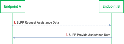
8.15.2.2.2 Assistance Data transfer procedure p. 164
Figure 8.15.2.2.2-1 shows the Assistance Data transfer operations for the SL-RTT positioning method.

Step 1.
Endpoint A may determine that certain SL-RTT positioning assistance data are desired and sends an SLPP Request Assistance Data message to Endpoint B. This request includes an indication of which specific SL-RTT assistance data are requested.
Step 2.
If step 1 occurred, Endpoint B provides the requested assistance in an SLPP Provide Assistance Data message to Endpoint A, if available at Endpoint B. The assistance data that may be signalled are listed in Table 8.15.2.2.2-1. If any of the requested assistance data in step 1 are not provided in step 2, the Endpoint A shall assume that the requested assistance data are not supported, or currently not available at Endpoint B. If none of the requested assistance data in step 1 can be provided by Endpoint B, Endpoint B returns any information that can be provided in an SLPP message of type Provide Assistance Data which includes a cause indication for the not provided assistance data.
If step 1 did not occur, Endpoint B determines that SL-RTT assistance data needs to be provided to Endpoint A (e.g., as part of a positioning procedure) and sends an SLPP Provide Assistance Data message to Endpoint A.
| Information |
|---|
| Application Layer ID, identifying a UE as defined in TS 23.287 |
| SL-PRS Sequence ID as defined in TS 38.211 |
| ARP ID, identifying an SL-PRS Tx ARP associated with a UE |
| Anchor UE location coordinates |
| SL-PRS Tx ARP location coordinates |
8.15.2.2.3 Location Information transfer procedure p. 165
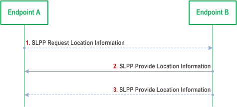
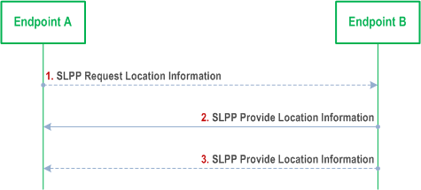
Figure 8.15.2.2.3-1 shows the Location Information transfer operations for the SL-RTT positioning method.

Step 1.
Endpoint A may send an SLPP Request Location Information message to Endpoint B. This request includes an indication of SL-RTT measurements requested, including any needed measurement configuration information, and possibly a required response time as listed in Table 8.15.2.2.3-1.
Step 2.
If step 1 occurred, Endpoint B obtains the SL-RTT measurements as requested in step 1. Endpoint B then sends an SLPP Provide Location Information message to Endpoint A, before the Response Time (if provided in step 1) elapsed, and includes the obtained SL-RTT measurements as listed in Table 8.15.2.2.3-2. If Endpoint B is unable to perform the requested measurements, or the Response Time elapsed before any of the requested measurements were obtained, Endpoint B returns any information that can be provided in an SLPP message of type Provide Location Information which includes a cause indication for the not provided location information.
If step 1 did not occur, Endpoint B may send an SLPP Provide Location Information message to Endpoint A. The SLPP Provide Location Information message may include any SL-RTT results already available at Endpoint B.
Step 3.
Optionally (e.g, if requested at step 1), Endpoint B may provide one or more additional SLPP Provide Location Information messages with SL-RTT measurements to Endpoint A (e.g., according to the periodic reporting criteria if received at step1).
| Information |
|---|
| Requested location information type (location estimate, location measurements, range estimate, range measurements) |
| Periodic reporting criteria |
| Positioning QoS (desired horizontal/vertical accuracy, desired range accuracy, response time, velocity request) |
| Environment information (expected multipath and non line of sight (NLOS) in the current area) Scheduled location time |
Requested measurement information:
|
| Information | SL Target UE-assisted | SL Target UE-based |
|---|---|---|
| Location estimate | No | Yes |
| Range estimate | No | Yes |
| Velocity estimate | No | Yes |
SL-RTT measurement information:
| Yes | No |
8.15.3 SL-AoA positioning p. 166
8.15.3.1 General p. 166
The SL-AoA positioning method makes use of SL angle of arrival measurements performed by a UE (e.g., target UE or anchor UE). The SL angle of arrival measurements performed by a UE of sidelink signals transmitted by a peer UE determines the azimuth and vertical angle (i.e., the direction) between the pair of UEs relative to a reference direction (e.g., geographical North).
8.15.3.2 SL-AoA positioning procedures p. 166
8.15.3.2.1 Capability transfer procedure p. 166
The capability transfer procedure for SL-AoA positioning is described in clause 7.11.2.1.
8.15.3.2.2 Assistance Data transfer procedure p. 166
Figure 8.15.3.2.2-1 shows the Assistance Data transfer operations for the SL-AoA positioning method.

Step 1.
Endpoint A may determine that certain SL-AoA positioning assistance data are desired and sends an SLPP Request Assistance Data message to Endpoint B. This request includes an indication of which specific SL-AoA assistance data are requested.
Step 2.
If step 1 occurred, Endpoint B provides the requested assistance in an SLPP Provide Assistance Data message to Endpoint A, if available at Endpoint B. The assistance data that may be signalled are listed in Table 8.15.3.2.2-1. If any of the requested assistance data in step 1 are not provided in step 2, the Endpoint A shall assume that the requested assistance data are not supported, or currently not available at Endpoint B. If none of the requested assistance data in step 1 can be provided by Endpoint B, Endpoint B returns any information that can be provided in an SLPP message of type Provide Assistance Data which includes a cause indication for the not provided assistance data.
If step 1 did not occur, Endpoint B determines that SL-AoA assistance data needs to be provided to Endpoint A (e.g., as part of a positioning procedure) and sends an SLPP Provide Assistance Data message to Endpoint A.
| Information |
|---|
| Application Layer ID, identifying a UE as defined in TS 23.287 |
| SL-PRS Sequence ID as defined in TS 38.211 |
| ARP ID, identifying an SL-PRS Tx ARP associated with a UE |
| Anchor UE location coordinates |
| SL-PRS Tx ARP location coordinates |
| Expected AoA and uncertainty |
8.15.3.2.3 Location Information transfer procedure p. 167
Figure 8.15.3.2.3-1 shows the Location Information transfer operations for the SL-AoA positioning method.
Step 1.
Endpoint A may send an SLPP Request Location Information message to Endpoint B. This request includes an indication of SL-AoA measurements requested, including any needed measurement configuration information, and possibly a required response time as listed in Table 8.15.3.2.3-1.
Step 2.
If step 1 occurred, Endpoint B obtains the SL-AoA measurements as requested in step 1. Endpoint B then sends an SLPP Provide Location Information message to Endpoint A, before the Response Time (if provided in step 1) elapsed, and includes the obtained SL-AoA measurements as listed in Table 8.15.3.2.3-2. If Endpoint B is unable to perform the requested measurements, or the Response Time elapsed before any of the requested measurements were obtained, Endpoint B returns any information that can be provided in an SLPP message of type Provide Location Information which includes a cause indication for the not provided location information.
If step 1 did not occur, Endpoint B may send an SLPP Provide Location Information message to Endpoint A. The SLPP Provide Location Information message may include any SL-AoA results already available at Endpoint B.
Step 3.
Optionally (e.g, if requested at step 1), Endpoint B may provide one or more additional SLPP Provide Location Information messages with SL-AoA measurements to Endpoint A (e.g., according to the periodic reporting criteria if received at step1).
| Information |
|---|
| Requested location information type (location estimate, location measurements, range estimate, range measurements) |
| Periodic reporting criteria |
| Positioning QoS (desired horizontal/vertical accuracy, desired direction accuracy, response time, velocity request) |
| Environment information (expected multipath and non line of sight (NLOS) in the current area) Scheduled location time |
Requested measurement information:
|
| Information | SL Target UE-assisted | SL Target UE-based |
|---|---|---|
| Location estimate | No | Yes |
| Direction estimate | No | Yes |
| Velocity estimate | No | Yes |
SL-AoA measurement information:
| Yes | No |
8.15.4 SL-TDOA positioning p. 169
8.15.4.1 General p. 169
The SL-TDOA positioning method makes use of SL-RSTD measurements of SL-PRS received at the target UE from two or more peer UEs (e.g., anchor UEs). The target UE measures the SL-RSTD of the received SL-PRS transmitted by two or more peer UEs. The Target UE position is estimated based on the SL-RSTD measurements and the knowledge of the geographical coordinates of the peer UEs (e.g., Anchor UEs) and their relative sidelink timing.
8.15.4.2 SL-TDOA positioning procedures p. 169
8.15.4.2.1 Capability transfer procedure p. 169
The capability transfer procedure for SL-TDOA positioning is described in clause 7.11.2.1.
8.15.4.2.2 Assistance Data transfer procedure p. 169
Figure 8.15.4.2.2-1 shows the Assistance Data transfer operations for the SL-TDOA positioning method.

Step 1.
Endpoint A may determine that certain SL-TDOA positioning assistance data are desired and sends an SLPP Request Assistance Data message to Endpoint B. This request includes an indication of which specific SL-TDOA assistance data are requested.
Step 2.
If step 1 occurred, Endpoint B provides the requested assistance in an SLPP Provide Assistance Data message to Endpoint A, if available at Endpoint B. The assistance data that may be signalled are listed in Table 8.15.4.2.2-1. If any of the requested assistance data in step 1 are not provided in step 2, the Endpoint A shall assume that the requested assistance data are not supported, or currently not available at Endpoint B. If none of the requested assistance data in step 1 can be provided by Endpoint B, Endpoint B returns any information that can be provided in an SLPP message of type Provide Assistance Data which includes a cause indication for the not provided assistance data.
If step 1 did not occur, Endpoint B determines that SL-TDOA assistance data needs to be provided to Endpoint A (e.g., as part of a positioning procedure) and sends an SLPP Provide Assistance Data message to Endpoint A.
| Information |
|---|
| Application Layer ID, identifying a UE as defined in TS 23.287 |
| SL-PRS Sequence ID as defined in TS 38.211 |
| ARP ID, identifying an SL-PRS Tx ARP associated with a UE |
| Anchor UE location coordinates |
| SL-PRS Tx ARP location coordinates |
| Synchronization information between anchor UEs |
8.15.4.2.3 Location Information transfer procedure p. 170
Figure 8.15.4.2.3-1 shows the Location Information transfer operations for the SL-TDOA positioning method.

Step 1.
Endpoint A may send an SLPP Request Location Information message to Endpoint B. This request includes an indication of SL-TDOA measurements requested, including any needed measurement configuration information, and possibly a required response time as listed in Table 8.15.4.2.3-1.
Step 2.
If step 1 occurred, Endpoint B obtains the SL-TDOA measurements as requested in step 1. Endpoint B then sends an SLPP Provide Location Information message to Endpoint A, before the Response Time (if provided in step 1) elapsed, and includes the obtained SL-TDOA measurements as listed in Table 8.15.4.2.3-2. If Endpoint B is unable to perform the requested measurements, or the Response Time elapsed before any of the requested measurements were obtained, Endpoint B returns any information that can be provided in an SLPP message of type Provide Location Information which includes a cause indication for the not provided location information.
If step 1 did not occur, Endpoint B may send an SLPP Provide Location Information message to Endpoint A. The SLPP Provide Location Information message may include any SL-TDOA results already available at Endpoint B.
Step 3.
Optionally (e.g, if requested at step 1), Endpoint B may provide one or more additional SLPP Provide Location Information messages with SL-TDOA measurements to Endpoint A (e.g., according to the periodic reporting criteria if received at step1).
| Information |
|---|
| Requested location information type (location estimate, location measurements) |
| Periodic reporting criteria |
| Positioning QoS (desired horizontal/vertical accuracy, response time, velocity request) |
| Environment information (expected multipath and non line of sight (NLOS) in the current area) |
| Scheduled location time |
Requested measurement information:
|
| Information | SL Target UE-assisted | SL Target UE-based |
|---|---|---|
| Location estimate | No | Yes |
| Velocity estimate | No | Yes |
SL-TDOA measurement information:
| Yes | No |
8.15.5 SL-TOA positioning p. 171
8.15.5.1 General p. 171
The SL-TOA positioning method makes use of SL-RTOA measurements performed at multiple peer UEs (e.g., anchor UEs). The target UE transmits SL-PRS and the peer UEs (e.g., anchor UEs) measures the SL-RTOA relative to the peer UEs (e.g., anchor UEs) own time base. The Target UE position is estimated based on the SL-RTOA measurements and the knowledge of the geographical coordinates of the peer UEs (e.g., Anchor UEs) and their relative sidelink timing.
8.15.5.2 SL-TOA positioning procedures p. 171
8.15.5.2.1 Capability transfer procedure p. 171
The capability transfer procedure for SL-TOA positioning is described in clause 7.11.2.1.
8.15.5.2.2 Assistance Data transfer procedure p. 171
Figure 8.15.5.2.2-1 shows the Assistance Data transfer operations for the SL-TOA positioning method.
Step 1.
Endpoint A may determine that certain SL-TOA positioning assistance data are desired and sends an SLPP Request Assistance Data message to Endpoint B. This request includes an indication of which specific SL-TOA assistance data are requested.
Step 2.
If step 1 occurred, Endpoint B provides the requested assistance in an SLPP Provide Assistance Data message to Endpoint A, if available at Endpoint B. The assistance data that may be signalled are listed in Table 8.15.5.2.2-1. If any of the requested assistance data in step 1 are not provided in step 2, the Endpoint A shall assume that the requested assistance data are not supported, or currently not available at Endpoint B. If none of the requested assistance data in step 1 can be provided by Endpoint B, Endpoint B returns any information that can be provided in an SLPP message of type Provide Assistance Data which includes a cause indication for the not provided assistance data.
If step 1 did not occur, Endpoint B determines that SL-TOA assistance data needs to be provided to Endpoint A (e.g., as part of a positioning procedure) and sends an SLPP Provide Assistance Data message to Endpoint A.
| Information |
|---|
| Application Layer ID, identifying a UE as defined in TS 23.287 |
| SL-PRS Sequence ID as defined in TS 38.211 |
| ARP ID, identifying an SL-PRS Tx ARP associated with a UE |
| Anchor UE location coordinates |
| SL-PRS Tx ARP location coordinates |
| Synchronization information between anchor UEs |
8.15.5.2.3 Location Information transfer procedure p. 172
Figure 8.15.5.2.3-1 shows the Location Information transfer operations for the SL-TOA positioning method.
Step 1.
Endpoint A may send an SLPP Request Location Information message to Endpoint B. This request includes an indication of SL-TOA measurements requested, including any needed measurement configuration information, and possibly a required response time as listed in Table 8.15.5.2.3-1.
Step 2.
If step 1 occurred, Endpoint B obtains the SL-TOA measurements as requested in step 1. Endpoint B then sends an SLPP Provide Location Information message to Endpoint A, before the Response Time (if provided in step 1) elapsed, and includes the obtained SL-TOA measurements as listed in Table 8.15.5.2.3-2. If Endpoint B is unable to perform the requested measurements, or the Response Time elapsed before any of the requested measurements were obtained, Endpoint B returns any information that can be provided in an SLPP message of type Provide Location Information which includes a cause indication for the not provided location information.
If step 1 did not occur, Endpoint B may send an SLPP Provide Location Information message to Endpoint A. The SLPP Provide Location Information message may include any SL-TOA results already available at Endpoint B.
Step 3.
Optionally (e.g, if requested at step 1), Endpoint B may provide one or more additional SLPP Provide Location Information messages with SL-TOA measurements to Endpoint A (e.g., according to the periodic reporting criteria if received at step1).
| Information |
|---|
| Requested location information type (location estimate, location measurements) |
| Periodic reporting criteria |
| Positioning QoS (desired horizontal/vertical accuracy, response time, velocity request) |
| Environment information (expected multipath and non line of sight (NLOS) in the current area) |
| Scheduled location time |
Requested measurement information:
|
| Information | SL Target UE-assisted | SL Target UE-based |
|---|---|---|
| Location estimate | No | Yes |
| Velocity estimate | No | Yes |
SL-TDOA measurement information:
| Yes | No |
![]()
![]()
![]()