Content for TR 22.843 Word version: 19.2.0
5.6 Use case on supporting UAV inflight operations
5.6.1 Description
5.6.2 Pre-conditions
5.6.3 Service Flows
5.6.4 Post-conditions
5.6.5 Existing features partly or fully covering the use case functionality
5.6.6 Potential New Requirements needed to support the use case
...
...
5.6 Use case on supporting UAV inflight operations p. 16
5.6.1 Description p. 16
For UAVs operated using the 3GPP network access, the network needs to ensure that the UAVs can use the network reliably and with adequate performance. UAV flight mission need to be monitored for the real-time performance and stability of flight control link to guarantee the safety and continuity of the flight.
5G network can provide wide-area, high-quality and secure connectivity that can enable cost-efficient UAV operations beyond visual line-of-sight. When UAV uses 3GPP network for communications, the UTM/UAV operator may need to monitor the network status along the flight path with the help of 3GPP network.
5.6.2 Pre-conditions p. 16
In the logistics company, UAV A and UAV B are both individual terminals for express delivery and subscribe the communication service from the 5G network.
Operator A provides 5G network coverage and communication services for remote commands and control (C2) communication between UAV and UAV control platform.
The UTM relies on Operator A to monitor and provide network status from the 5G network for UAV inflight related information.
5.6.3 Service Flows p. 17
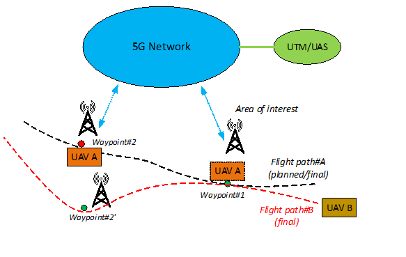
- The logistics company uses UAV A and UAV B to perform delivery operations. UAVs planned flight paths shared a common portion, along waypoint #1 and waypoint #2.
- UAV/UAV-C A and UAV/UAV-C B register in 5G network and can communicate with UTM though 5G network.
- The UAV-C A provides planned flight path #A information to UTM (e.g., flight path and required QoS along the planned flight path).
- UAV A receive the flight path information from UTM/UAS via 5G network and start flight mission.
- UTM requests 5G network for network condition information (e.g., bitrate, latency, reliability) along the flight path of UAV A.
- The 5G network provides the requested statistics (e.g., end-to-end latency, QoE) for specific requested area/areas (e.g., degraded QoE at waypoint #2).
- The UAV-C B provides planned flight path #B (along waypoint #1 and waypoint #2) information to UTM.
- UTM/UAS determines the final flight path #B (e.g., adjusted to take waypoint #2') and scheduling for UAV/UAV-C B based on the information from Operator A along UAV A flight route, and sends it to UAV/UAV-C B.
- UAV B receive the flight path #B information from UTM/UAS via 5G network and start flight mission.
5.6.4 Post-conditions p. 17
UAV A and UAV B can finish their delivery tasks with the support of 5G network.
5.6.5 Existing features partly or fully covering the use case functionality p. 17
Existing related service requirements are captured in clause 6.2 of TS 22.125 "Network exposure for UAV services".
[R-6.2-001]
The 3GPP system shall provide means to allow a 3rd party to request and obtain real-time monitoring the status information (e.g., location of UAV, communication link status) of a UAV.
[R-6.2-002]
Based on operator's policy, the 3GPP system shall provide means to provide a 3rd party with the information regarding the service status for UAVs in a certain geographical area and/or at a certain time.
These requirements do not include explicit requirements on QoS related network conditions like bitrate, latency and reliability.
5.6.6 Potential New Requirements needed to support the use case p. 18
[P.R 5.6.6-001]
Based on operator's policy, the 5G system shall be able to provide a method to monitor and provide a 3rd party with information about network conditions and QoS (e.g. bitrate, latency, reliability) along a UAV flight path.
[P.R 5.6.6-002]
Based on operator's policy, the 5G system shall be able to provide a method to monitor and provide a 3rd party with information about deviations and violations along a UAV flight path and time.
![]()
![]()
![]()