Content for TR 22.856 Word version: 19.2.0
1…
5…
5.2…
5.3…
5.4…
5.5…
5.6…
5.7…
5.8…
5.9…
5.10…
5.11…
5.12…
5.13…
5.14…
5.15…
5.16…
5.17…
5.18…
5.19…
5.20…
5.21…
5.22…
5.23…
5.24…
5.25…
5.26…
5.27…
5.28…
6
7…
7.2
8
A
B
C…
5.5 Use Case on Spatial Mapping and Localization Service Enabler
5.5.1 Description
5.5.2 Pre-conditions
5.5.3 Service Flows
5.5.4 Post-conditions
5.5.5 Existing feature partially or fully covering use case functionality
5.5.6 Potential New Requirements needed to support the use case
5.5.6.1 Requirements for Spatial Mapping
5.5.6.2 Requirements for Localization
...
...
5.5 Use Case on Spatial Mapping and Localization Service Enabler p. 29
5.5.1 Description p. 29
Spatial mapping is constructing or updating a map of an unknown location and localization is tracking an object to identify its location and orientation over time.
For the localized mobile metaverse use case 5.1, the service provider or operator needs to provide and use spatial map information, i.e. a 3D map of indoor or outdoor environment. This use case considers how a spatial map can be created and employed, both as service enablers. The creation and maintenance of the spatial map is referred to as Spatial Mapping Service and the employment of the map to identify the customer's Localization is termed Spatial Localization Service.
Spatial mapping will classify objects into modelling and tracking of stationary and moving objects. For stationary object, spatial mapping has to estimate the number of objects, type of object and position. Whereas for moving objects, spatial mapping has to determine the position, type of object, direction, speed. Once the spatial mapping service has sufficient information, it has to map all the stationary and moving objects related to UE's environment. This information can be provided to the UE, service providers and surrounding subscribed users as well [17], [19], [24].
Specifically, this use case proposes two spatial localization service enablers.
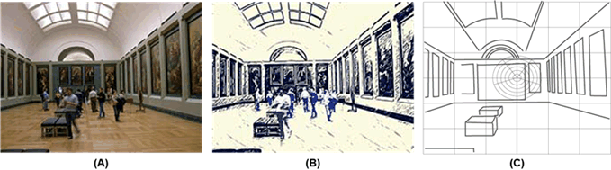
- Spatial Mapping Sensing data gathered transparently is processed in order to identify the static and transient forms. For example, in Figure 5.5.1-1
- the Rubens room in the Louvre, sensing data captures information.
- This information is processed to identify the static and transient information, to establish an up-to-date spatial map.
-
In combination with location information (for the sensors) and other information (e.g. architectural specifications of the Louvre), a spatial map can be achieved in which not only the forms but also their locations in 3D space are known.
-
Localization
Given that a spatial mapping exists,
- sensing data for a user (from devices communicating by means of a UE) can be captured,
- compared with the spatial map,
- used to identify in 3D space the position, viewing direction, angle, etc. of the user.
Examples when spatial mapping could be useful:
Localization Considerations
- A government conducting a digital city project can build a 3D spatial map of outdoor environment of an entire city or public spaces such as outdoor parks or indoor offices of their government building.
- A navigation service provider (or Spatial Localization Service) can build a 3D spatial map of outdoor environment of entire roads or public spaces. An operator's partner or operator also can build a 3D spatial map of outdoor environment.
- A customer wanting mapping of their indoor environment, e.g. the interior of a commercial space such as the cheese shop as described in 5.4.
The environment mapping can be used for providing a visual positioning service, for enhancing the accuracy of location service or for helping the metaverse contents management system for spatial internet.
In this use case, the UE provides uplink sensor information that can be interpreted, along with a spatial map, to identify Localization. This is analogous to the process used by the UE to provide sensor data that the 5G system can use to determine UE location for Location Services.
5.5.2 Pre-conditions p. 30
For Spatial Mapping
Mobile operator or service provider can determine the target area for the spatial mapping. The target area can be divided into multiple areas where each can be mapped with multiple capturing devices (e.g. capturing indoor robot, vehicles).
Each capturing device is equipped with multiple sensors, e.g. mono or stereo RGB camera or one or more multiple LiDAR cameras. The intrinsic parameter of cameras equipped with the device are pre-configured in the device.
Each capturing device has a capability with high resolution positioning system, the positioning technique also can derive the altitude information.
An indoor robot can be equipped with non-3GPP based high resolution positioning system such as UWB. To derive the exact the position of the capturing device, each capturing device also can utilize the structure-from-motion technologies.
The capturing devices communicate via a UE that can access the mobile network of the MNO that supports spatial mapping. The capturing devices can either sense the spatial area to be mapped, or move about sufficiently that the capturing devices can be used to acquire sensing data corresponding to the area.
For Localization
A set of sensors are accessible by a UE. These could be built into the terminal equipment or communicate with it in some way that is out of scope of this use case, e.g. using a cable, a personal area network, etc.
The UE can access a mobile network of MNO M that offers localization services.
In 3GPP-R16, bistatic localization is performed on both downlink and uplink using time-difference-of-arrival (TDoA), angle-of-arrival (AoA), and angle-of-departure (AoD) measurements both at the base station. Both bistatic and monostatic have limitation with their accuracies, with the advent of high BW mmWave brings high resolution in both time-delay and angle domains. The spatial mapping problem can be divided into front and a back-end problem. In front-end, the problem is to determine the data association - between landmarks and measurement directions. The back-end problem is to find the probabilistic SLAM density for a given data association- determined in the front end. Most of the back-end algorithms are Kalman filter (EKF), Fast-SLAM and Graph-SLAM, which are based on Bayesian method [21], [22], [23].
5.5.3 Service Flows p. 31
For Spatial Mapping
- A capturing mobile device attaches to the mobile network and becomes authorized to deliver sensing data for the purposes of spatial mapping.
- The capturing mobile device starts the mapping operation.
- The capturing mobile device arranges for its sensors to provide information as needed by the 5G system. This could require some configuration of the capturing mobile device, e.g. the sensors or to control the uplink communication of sensing data.
- The capturing mobile device navigates, e.g. with a pre-defined route, within the selected target region in order to provide a sufficiently complete set of sensor information for the space to be mapped.
- The capturing mobile device uploads the captured RGB camera images and LIDAR depth images to the 5G system with the positioning information of the mobile device.
- The mapping server collects and analyzes the information provided to cumulative create or update a spatial map.
- A mobile device requiring localization attaches to a mobile network and becomes authorized to obtain Localization services.
- The mobile device uses sensors to capture information corresponding to the point and direction that has to be localized.
- The mobile device sends via uplink communication the sensing data to the 5G system.
- The 5G system uses the sensing data and a spatial map to determine the localization, that is, the corresponding positioning information and sensor pose.
5.5.4 Post-conditions p. 31
For Spatial Mapping
The spatial mapping enabler re-structures the data provided by mobile capture devices to create a spatial map. This information could be combined with other information available, e.g. floor plans of buildings, survey data, satellite images, etc. Over time sufficient information will be captured to allow the spatial mapping enabler to distinguish between static and dynamic objects in the environment.
For Localization
The result of the localization service is available as a service enabler. This could be provided to the UE for use by applications or exposed to a third party by means of an API by the 5GS. This information can be used for many purposes, especially for media based applications that require localization to control the rendering of AR or MR content. Localization can be done over time, e.g. to track a user's movement.
The localization enabler can enhance location services as it can identify with some degree of precision a location by means of diverse sensors compared with known location data in the spatial map.
5.5.5 Existing feature partially or fully covering use case functionality p. 32
Location Services provide location information which can be used to support services that are triggered or informed by the user's location. This information is not at the degree of accuracy needed for some applications, e.g. AR. Location Services also do not work in all environments, e.g. indoor.
The 5GS supports uplink media and uplink sensor data communication.
In clause 4.1.4 of TR 26.928 - XR spatial mapping and localization - has been proposed. This use case specifies the key areas of XR and AR are spatial mapping, which is creating a map of the surrounding areas, and localization - positioning the user in that map. This use case depends on multiple external sensors such as monocular/stereo/depth cameras, radio beacons, GPS, inertial sensors, etc., There is no requirement on how 5G sensing can be used for spatial mapping and localization services.
Positioning in 5G Networks been proposed in 3GPP release-16, it specifies positioning signals and measurements for the 5G NR. In release-16, 5G Positioning architecture extends 4G positioning architecture by adding Location Management Function (LMF) and Transmission reception points (TRP). 5G- along with enables- provides new positioning methods based on multi-cell round-trip time measurements, multiple antenna beam measurements, multiple to enable downlink angle of departure (DL-AoD) and uplink angle of arrival (UL-AoA) [M, 21, 22]. Current 5G system supports positioning of the device-based but not device-free - Objects that do not radiate EM signals. We propose to add new requirement in clause 5.5.6 to extend this architecture to support spatial mapping and localization service enablers.
5.5.6 Potential New Requirements needed to support the use case p. 32
5.5.6.1 Requirements for Spatial Mapping p. 32
[PR 5.5.6.1-1]
Subject to operator policy and relevant regional and national regulation, the 5GS shall support mechanisms for an authorized UE to provide sensing data that can be used to produce or modify a spatial map.
[PR 5.5.6.1-2]
Subject to operator policy, user consent and relevant regional and national regulation, the 5GS shall support mechanisms to receive and process sensing data to produce or modify a spatial map.
[PR 5.5.6.1-3]
Subject to operator policy and relevant regional and national regulation, the 5GS shall support mechanisms to expose a spatial map or derived localization information from that map to authorized third parties.
[PR 5.5.6.1-4]
The 5G system shall support the collection of charging information associated with the exposure of a spatial map or derived localization information to authorized third parties.
[PR 5.5.6.1-5]
The 5G system shall support the collection of charging information associated with the production or modification of a spatial map on behalf of an authorized third party.
5.5.6.2 Requirements for Localization p. 32
[PR 5.5.6.2-1]
Subject to operator policy and relevant regional and national regulation, the 5GS shall support mechanisms to authorize Spatial Localization Service.
[PR 5.5.6.2-2]
Subject to operator policy and relevant regional and national regulation, the 5GS shall support mechanisms for an authorized UE to provide sensor data that can be used to for Spatial Localization Service.
[PR 5.5.6.2-3]
Subject to operator policy and relevant regional and national regulation, the 5GS shall support mechanisms to expose Spatial Localization Service information to authorized third parties.
[PR 5.5.6.2-4]
The 5G system shall support the collection of charging information associated with exposing spatial location service information to authorized third parties.
![]()
![]()
![]()