Content for TR 22.843 Word version: 19.2.0
5.10 Use case on UAV control in different aerial flight zones
5.10.1 Description
5.10.2 Pre-conditions
5.10.3 Service Flows
5.10.4 Post-conditions
5.10.5 Existing features partly or fully covering the use case functionality
5.10.6 Potential New Requirements needed to support the use case
5.10 Use case on UAV control in different aerial flight zones p. 24
5.10.1 Description p. 24
5G networks can provide connectivity to UAV for a variety of services, e.g., command and control, telemetry, remote ID, DAA, payload transfer (e.g., video), etc. In some scenarios, it would be beneficial to control and differentiate UAV operation and communication, e.g., regarding the use of specific network resources and/or specific application(s) settings, in different geographical areas. Some aspects of the 5G connectivity configuration, indeed, may need to be different depending on the area where the UAV is flying, e.g., in urban versus rural, or in areas close to high-risk obstacles or with stricter safety restrictions, like airports, stadiums, etc. This use case describes some means to efficiently support and control differentiation of UAV traffic across different zones and corresponding potential requirements.
For example, the UAV and UTM provider may identify different types of aerial flight zones in the territory, e.g., based on data traffic information, flight statistics, network topology. local conditions, events, etc. Based on business agreement with an MNO, the UTM and network can configure specific information on different flight zones, which can include e.g., the geographical location (footprint or 3D volume) of the flight zones and their mapping to different network areas, associated zone type or other means to identify a specific flight zone, and target UAV communication/QoS parameters (per flight zone).
UTM and/or the network can then convey to the UAV corresponding policy configuration (static or dynamic), controlling how the UAV should use connectivity services for various applications in different flight zones (e.g., per zone type). The network should also assist UAV to identify and differentiate specific flight zones, so that a UAV can apply the right configured policy based on the actual flight zone it is currently located in.
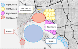
A general example of flight zones settings is illustrated in Figure 5.10.1-1, based on different geographical, logistical and safety factors (e.g., around city centre, stadiums, airports, harbour, rural areas, etc.). The Figure may represent the flight zone settings for a specific day, or time of the day, and may vary based on local/temporary change of conditions.
The UAV policy could also contain a default configuration that can be used when no specific flight zone type is applicable or not indicated/available to the UAV.
The above would provide the ability for UTM to collaborate with the 5G network to provide flexible control of UAV communication over the identified flight zones, including scalable and dynamic adaptation based on temporary/local changes (e.g., data traffic, NW resources, environmental changes, local events or restrictions), by creating new flight zones that map on specific network areas and/or modifying existing zone types, etc.
One specific scenario and flow is further elaborated below.
5.10.2 Pre-conditions p. 25
A UAV service provider (U-Serv), offering monitoring & surveillance UAV services in multiple cities of the country, has an agreement with PLMN-A operator, including the configuration of two different flight zones (for all cities) mapped to different parts of the territory and network, with the following UAV application/traffic policies and conditions:
-
Zone A (no restriction/condition): for most areas/location of the cities' territory
- normal/default UAV application and communication settings
-
Zone B (with restriction/condition): for areas/locations e.g., with larger data traffic/congestion and/or higher drones' density (e.g., where/when special events or emergency situations happen).
- Increased frequency and QoS of C2 communication (for more reliable command and control operation)
- Reduced data traffic activity/QoS for other communications (to reduce network congestion)
5.10.3 Service Flows p. 25
- A U-Serv UAV, located in Zone A, is registered to PLMN-A and starts its daily surveillance service.
- The UAV detects it is in Zone A, e.g., if indicated by the network or based on UAV available information or pre-configuration, and connects to the network using the corresponding traffic policy for Zone A (normal/default operation).
- Along the UAV itinerary, UAV detects or is notified of being in a new zone type, Zone B, thus UAV application will apply corresponding traffic settings according to Zone B policy.
- If UAV detects or is notified that flight zone type changes to Zone A, UAV application will switch back to default traffic policy.
5.10.4 Post-conditions p. 26
U-Serv UAV application can provide smooth service and is able to adapt its communication settings when flying across special locations/areas (zone B), based on UAV traffic policies and flight zone settings under control of UTM and network.
5.10.5 Existing features partly or fully covering the use case functionality p. 26
None identified.
5.10.6 Potential New Requirements needed to support the use case p. 26
[PR 5.10.6-001]
The 5G system shall be able to support mechanisms for the UTM to configure different aerial flight zones where UAV application settings and communication QoS may be different, and provide network and UAV with means to identify those flight zones.
[PR 5.10.6-002]
The 5G system shall be able to support mechanisms for the UTM to provide network and UAV with policy information including UAV application settings and communication QoS to be applied in specific aerial flight zones, e.g. based on flight zone type indicated or available to the UAV in a certain geographical location.
![]()
![]()
![]()