Content for TR 22.837 Word version: 19.3.0
0…
4
5…
5.2…
5.3…
5.4…
5.5…
5.6…
5.7…
5.8…
5.9…
5.10…
5.11…
5.12…
5.13…
5.14…
5.15…
5.16…
5.17…
5.18…
5.19…
5.20…
5.21…
5.22…
5.23…
5.24…
5.25…
5.26…
5.27…
5.28…
5.29…
5.30…
5.31…
5.32…
6…
7…
5.5 Use case on sensing for flooding in smart cities
5.5.1 Description
5.5.2 Pre-conditions
5.5.3 Service Flows
5.5.4 Post-conditions
5.5.5 Existing features partly or fully covering the use case functionality
5.5.6 Potential New Requirements needed to support the use case
...
...
5.5 Use case on sensing for flooding in smart cities p. 24
5.5.1 Description p. 24
Due to the climate change in recent years, a larger amount of rain sometimes falls within a short duration of time inside a small area. This result, in particular in urban areas, in inundation and flooding even in areas where these did not happen in the past. When flooding is about to happen on roads, people might enter areas getting in danger without knowing it. Once flooding really happens there, this might result in loss of human life. At places where flooding is expected to occur, monitoring of flooding is performed using cameras and other sensors. However, due to the recent climate change, it can be difficult to recognize places where flooding is expected to occur. Using radio waves, it is possible to recognize places where flooding occurs in an efficient way.
5.5.2 Pre-conditions p. 24
Good partnership and cooperation are established between Mobile Operator #A and administrators of roads such as a local government in City #B. Mobile Operator #A constantly senses the surface of the road and informs results of sensing to the administrator of the road.
5.5.3 Service Flows p. 24
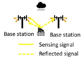
- Base stations owned by Mobile Operator #A are deployed around the road. Mobile Operator #A carries out sensing of the surface of the road in City #B. This sensing is performed using radio wave. Results of sensing information, incl. whether flooding occurs on the road, are informed to the administrator of the road in City #B.
- The administrator of the road usually monitors the state of flooding on the road using information from sensors including information from Mobile Operator #A. In addition, in the case of heavy rain, the administrator can request Mobile Operator #A to increase frequency of monitoring of situation of roads and Mobile Operator #A monitors the situation more frequently responding to this request.
- If there is information received that flooding occurs, the administrator advises people in the areas concerned to evacuate the areas. The administrator advises via mobile networks.
- People who received the advice evacuate the areas or do not enter such areas.
- Now City #B trusts Mobile Operator #A and allows it to advise people about evacuation without City #B's intervention in case of flooding. Next time a similar flooding occurs, Mobile Operator #A sends advice for evacuation directly to people.
5.5.4 Post-conditions p. 25
Damage of the flooding has been kept at minimum.
5.5.5 Existing features partly or fully covering the use case functionality p. 25
None.
5.5.6 Potential New Requirements needed to support the use case p. 25
[PR 5.5.6-1]
Subject to operator policy, the 5G system shall be able to provide sensing result indicating disasters or other emergencies (e.g., flooding) in a given geographic area to authorized third parties in a timely manner.
[PR 5.5.6-2]
Subject to regional or national regulatory requirements and operator policy, the 5G system shall be able to provide its public warning system with a warning notification based on sensing result indicating disasters or other emergencies (e.g., flooding) in a given geographic area in a timely manner.
[PR 5.5.6-3]
Subject to operator policy, it shall be possible for an authorized third party to configure the 5G system to initiate sensing for disasters or other emergencies (e.g., flooding) in a given geographic area.
[PR 5.5.6-4]
The 5G system shall be able to support the following KPIs:
| Scenario | Sensing service area | Confidence level [%] | Accuracy of positioning estimate by sensing (for a target confidence level) | Accuracy of velocity estimate by sensing (for a target confidence level) | Sensing resolution | Max sensing service latency[ms] | Refreshing rate [s] | Missed detection [%] | False alarm [%] | |||
|---|---|---|---|---|---|---|---|---|---|---|---|---|
| Horizontal
[m] |
Vertical [m] | Horizontal [m/s] | Vertical [m/s] | Range resolution [m] | Velocity resolution (horizontal/ vertical) [m/s x m/s] | |||||||
| sensing for flooding in smart cities | Outdoor | 95 | ≤10 | [≤0.2]
NOTE 2 | N/A | N/A | N/A | N/A | ≤ 1min
NOTE 3 | < 1min
NOTE 3 | < 0.1 | < 3 |
|
NOTE 1:
The terms in Table 5.5.6-1 are found in clause 3.1.
NOTE 2:
This value is for the water level. Description related to NOTE in clause 5.5.1 suggests 0.01 m. [≤0.2] is derived from the water level where people feel difficulty in walking.
NOTE 3:
Description related to NOTE in clause 5.5.1 suggests 2 minute-interval monitoring when the water level of the river rises quickly.
|
||||||||||||
![]()
![]()
![]()